

Winter Storm-Cycle Forecast
What the Tea Leaves Are Telling Us


While most people are still sweating through the August heat and planning their last poolside sessions, serious riders are already eyeing the horizon for what Winter 2025/’26 might deliver. Call it obsessive, call it strategic planning, but if you’ve been in this shred game long enough, you know that understanding the seasonal forecast can make the difference between scoring deep January face shots and sitting on your couch watching retro, VHS snowboard films.
After more than three decades of chasing storms across North America, I’ve learned that the ocean currents thousands of miles away in the Pacific ultimately dictate whether we’re dropping into champagne powder or scraping our bases on wind crust. So let’s dive into what the meteorological crystal ball is showing us for the upcoming season.
The Pacific Ocean’s Pulling the Strings
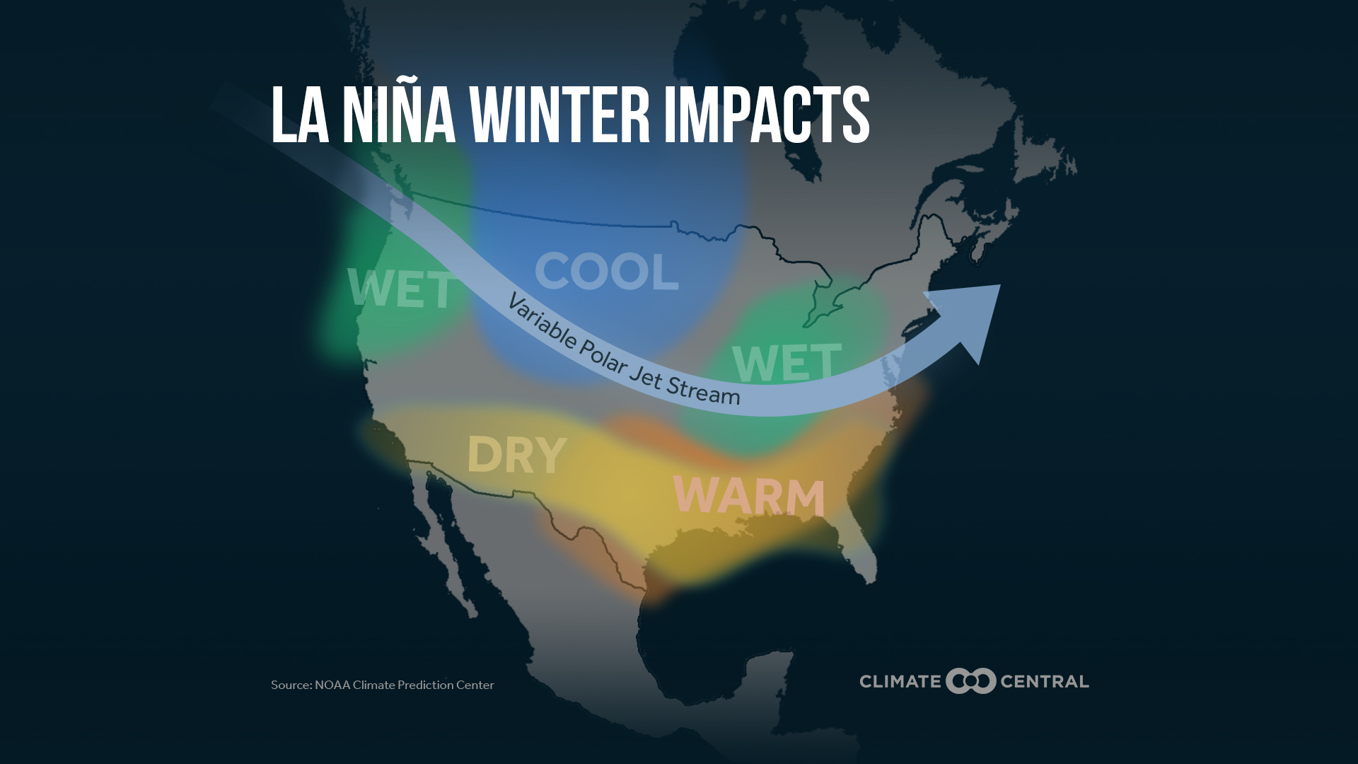
The Pacific is holding steady with El Niño Southern Oscillation (ENSO) -neutral conditions through late summer, but moving into fall and winter, there’s a slightly rising chance for La Niña to develop. For those keeping score at home, NOAA’s Climate Prediction Center gives La Niña about a 50% chance of emerging between October 2025 and January 2026. That might not sound definitive, but in the world of long-range forecasting, 50% is practically a sure thing.
Why should you care about some water temperatures in the middle of the Pacific? Because La Niña is the cool phase of the ENSO cycle, characterized by colder-than-average sea surface temperatures in the equatorial Pacific Ocean. This phenomenon influences global weather patterns, often bringing cooler conditions to the northern United States and Canada. In plain English: La Niña tends to load the dice in favor of the regions we actually want to ride.
The beauty of La Niña winters lies in how they reorganize the jet stream. A La Niña-cooled Pacific tends to shunt storms north into British Columbia, the Cascades and the northern Rockies while leaving the Southwest and Southern California thirstier. If you’re sitting in Whistler, Fernie, B.C., or Jackson Hole right now, you should be cautiously optimistic. If you’re banking on another epic Mammoth season, well, maybe keep your expectations in check.
Regional Breakdown: Where the Goods Will Be
Pacific Northwest and Northern Rockies: The Golden Zone
This is where La Niña shows its love most consistently. Models favor more typical La Niña-like patterns, with increased chances of above-normal precipitation (snow) in the Northern Rockies and around the Great Lakes/Ohio Valley. Translation: the PNW and northern interior mountains are looking at what could be a stellar season.
We’re talking about resorts like Mt. Baker, Crystal Mountain, WA, Whistler, Fernie, and Jackson potentially seeing above-average snowfall. The storm track during La Niña winters tends to favor these regions with consistent Pacific moisture getting lifted over the mountains and dumped as snow rather than rain.
Colorado and Central Rockies: The Wild Card
Colorado always plays by its own rules, and this season looks to continue that tradition. Drier-than-average conditions persist across the Southern Rockies and Southwest early in the season, but things could shift dramatically as winter progresses.
Utah finds itself in an interesting position … The Wasatch sits right in the transition zone between the favored northern regions and the potentially drier southern areas. This means resorts like Alta, Snowbird, Park City, and Deer Valley could see feast-or-famine conditions depending on exactly where the storm tracks set up. Utah’s elevation advantage will be crucial this season, especially if early storms come in warm. The good news is that Utah’s continental snowpack tends to respond quickly when the pattern does shift favorable.
The forecast suggests a mild and wet start to the season, but with growing potential for significant cold air outbreaks, snowstorms, and wintry extremes in February due to weakening of the polar vortex. For Utah and Colorado riders, this could mean a frustrating start followed by some absolutely epic late-season powder days. If the polar vortex weakens as predicted, both states could see some legitimate cold snaps that turn marginal storms into proper powder dumps.
California and the Southwest: Patience Required
If you’re holding a season pass to Mammoth, Squaw (aka Palisades Tahoe), or anywhere in the Sierra Nevada, the early forecast isn’t exactly lighting up the stoke meter. Drier-than-average conditions persist across the Southern Rockies and Southwest is the predominant signal.
However, wetter-than-average conditions expected in California early in the season. Enhanced snowpack for the Sierras and Cascades suggests there might be some redemption, particularly if the pattern shifts mid-winter. The key will be staying flexible and ready to chase the storms when they do hit.
East Coast: The Dark Horse
Here’s where things get interesting. Above-normal precipitation is favored, offering hope for strong base-building and memorable Nor’easters. The East Coast could surprise people this year, especially if the polar vortex decides to get wobbly and send some legitimate Arctic air masses south.
New England mountains like Stowe, Killington, and Jay Peak, Vermont could see cold temperatures and above-normal snowfall potential, especially in December and January. The Great Lakes region is also showing promise for consistent snow, which is great news for the Midwest crew.
The Polar Vortex Wild Card
Here’s where the forecast gets really intriguing. Strong early signs suggest a different type of polar vortex will develop. Early data shows strong signs that it’s likely to be weaker than normal.
A weak polar vortex is like hitting the lottery for snowboarders in the Lower 48. A weak polar vortex creates a disrupted jet stream pattern and has a harder time containing the cold air, which can now more freely escape from the polar regions into the U.S. This could mean legitimate powder days in places that don’t usually see them, and absolutely insane conditions in the regions that do.
The timing looks particularly promising for February, when Arctic air outbreaks, late-season snowstorms, and polar vortex disruptions are most likely. Mark your calendars and keep some vacation days in reserve for late winter.
Pattern Evolution: A Tale of Two Halves
The most consistent theme across all the forecasts is that winter is likely to be a story of two distinct acts: front-loaded with mild and wet conditions in the southern and eastern U.S., but with growing potential for significant cold air outbreaks, snowstorms, and wintry extremes in February.
December and January might feel frustratingly mild in many areas, especially across the southern tier of the country. But if the polar vortex forecasts pan out, February could deliver some absolutely legendary conditions. The key will be staying patient through what might be a slow start and being ready to pounce when the pattern shifts.
What This Means for Your Season Planning
Based on thirty-plus years of watching these patterns play out, here’s my take on how to approach the season:
Book Early in the PNW and Northern Rockies: If you’re planning a destination trip, the Pacific Northwest and northern interior mountains are your best bet for consistent conditions. Don’t wait for deals, book those Whistler and Jackson trips now.
Stay Flexible in Colorado: Colorado could go either way. Come February and March … things could get absolutely wild.
Watch California Closely: The Sierras might surprise people, but it’s going to require patience and the ability to move quickly when storms do hit.
Don’t Sleep on the East Coast: This could be a sleeper season for New England and the Great Lakes. If you’re within driving distance, keep your calendar flexible for those potential Nor’easter cycles.
Save Some Personal Days for February: Seriously, if the polar vortex forecasts verify, February could be one for the history books.
The Last Word
Look, long-range forecasting is part science, part art, and part educated guessing. Ocean temperatures in the Pacific don’t care about your season pass or your powder dreams. But if you’ve been riding long enough, you know that understanding these patterns gives you an edge.
The 2025/26 season is shaping up to reward the patient and the prepared. La Niña typically shifts the jet stream, promoting a strong high-pressure system in the North Pacific. This redirects cold air southward, increasing snowfall potential in northern ski areas. Combined with the potential for a weak polar vortex, we could be looking at a season that starts slow but finishes with a bang.
My advice? Get your gear dialed, keep your schedule flexible, and remember that the best powder days always go to those who show up ready to ride, regardless of what the forecast says. The mountains will do what they do, and our job is to be ready when they deliver.
The storm cycles are coming. The question isn’t if, but when and where. And for those of us who live for these moments, that’s exactly how we like it.
